Anyone can search for "Camp Site" in a web browser, but you know how that goes. The POI in Overland Bound One have been added by fellow Overland Bound Members with vital information about that location.
Prefer a video app tutorial? See it here!

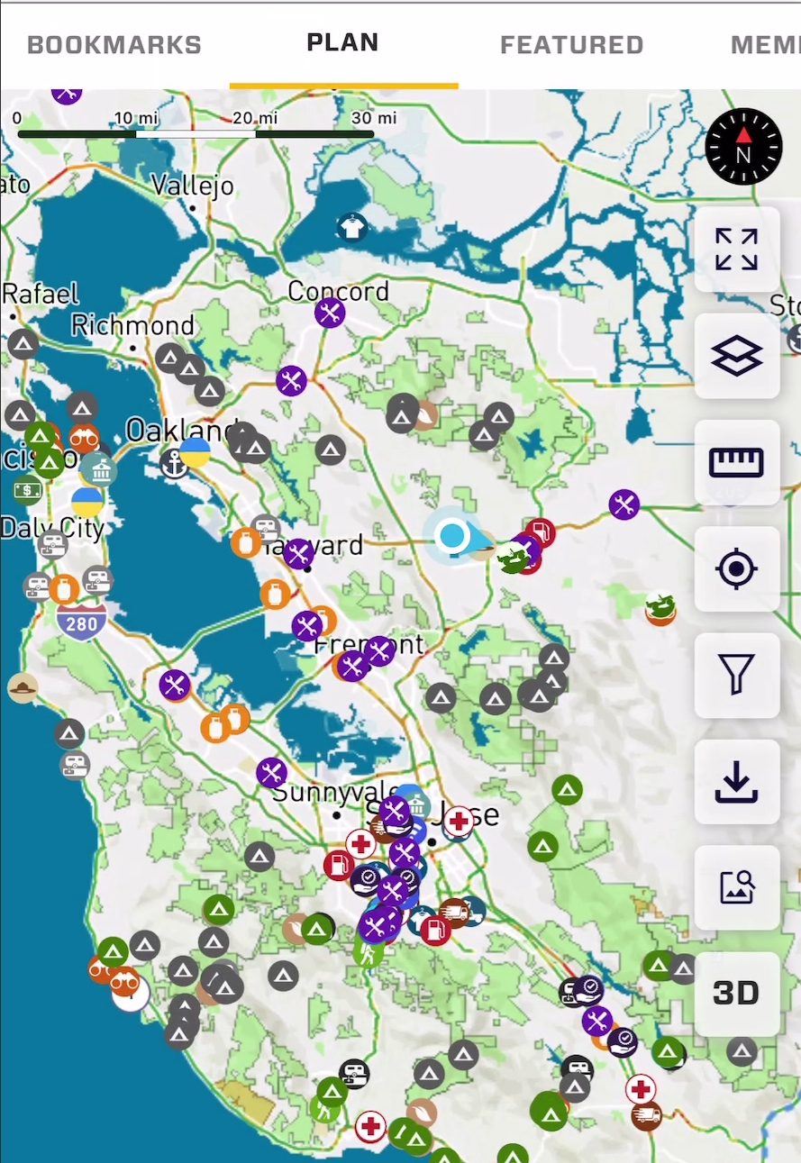
Points of interest are represented by icons on the map. POI or "Resources" can be Verified or unverified.
Any Resource additions or Reviews contributes to your community rank. Trophies will be earned!
Unverified Resources: These show with a grey icon, and it means the location has not been verified by a member of the community. Unverified resources will be verified when a member of the community reviews the resource, confirming the quality of the location. The location will go through the administration approval process, and the icon will become a color icon.
Verified Resources: These resources have a color icon and they were added by a member of the community. They also went through our administrator approval process where we check to be sure the location is what it says it is, and in the right location.
Zooming in and clicking a single POI icon will bring up its summary card. Tapping a collection of POI icons will bring up a scrollable list of all POI in the area.
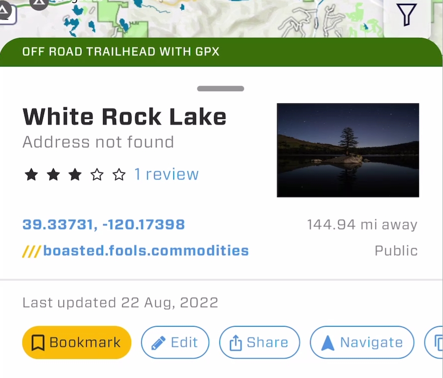
Summary Card:
The summary card will quickly display summary information of a POI and also provide valuable tools. Information on the summary card:
Resource Title:
Address: A street address if the location is on a known street.
Reviews: Score and count. You may also tap the count to go to the review page to see all reviews. This can be helpful to get up to date information.
GPS Coordinates: The GPS coordinates of the location. These coordinates can be tapped to copy them to the clipboard.
3 Word Address: GPS coordinates to hard to read off or remember? Provide the three word address instead. The three word address may also be tapped to copy to the clipboard. The three word address may be used in the OB1 Map Search tool, or any application supporting What 3 Words. Three word addresses are accurate to 3 meters.
Distance from your current location:
Privacy: Most location you see will be "Public", however, if you have added a location to OB1 and made it Private, no one else will see it, and this information will say "Private" in the summary card.
Summary Card Tools:
There are a number of scrollable tools on the summary card. The blue buttons along the bottom.
Bookmark: This button will make the location visible on the "Bookmarks" map tab. It is a great way to save Resources for a specific trip or any other reason. In the future, this will likely become the "Main Map" which will show all bookmarked locations.
Edit: if this is a location you have added, you will see an "Edit" button, allowing you to update or edit any information.
Share: Allows you to share the location with any other person who has OB1. Their app will open to the Resource Summary Card. If they do not have OB1 installed, they will go to a web page allowing them to download and install OB1.
Navigate: Will allow you to choose a popular navigation app of your choice for turn-by-turn street navigation to the Resource location.
Copy: This will copy the street address to the clipboard if one exists.
Resource Detail Page
The resource detail page provides all information added by the author, as well as reviews by other folks who have visited the area.
Every Resource POI location type has unique details and tools relevant to the Resource location type.
Menu: if you are the author, you will see a three-dot menu providing access to edit this locations.
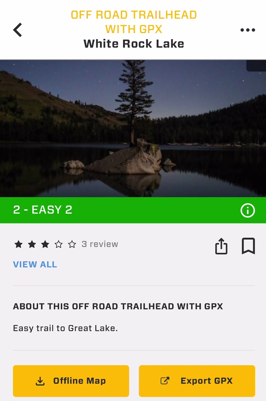
Feature Image: This image is the first image added by the author. In the case of a location that was unconfirmed, if a member reviews a location and adds a photo, this photo will become the feature image for this location, and the location will become verified.
Difficulty Rating (Offroad Trailhead Only): Provides the difficulty rating of the trail. The "i" information icon will provide the definition of that rating level. This rating is color coded and matches the trail color on the map.
Reviews: Link to see all reviews.
Share: A share icon with the same functionality as the Summary Card.
Bookmark: Bookmark this location to show on the Bookmark or Main Map map tab.
Description: Details added by the author.
Download Offline Map (Off-road trailhead only): This will download the map for offline use around the exact area of the trail + 5 miles.
Export GPX (Off-road trailhead only): Export the GPX track to share with another user.
Location Details: Provides all details added by the author. This also has location info in many formats to which can be copied by tapping the blue text.
Suggest an edit: This is a location flag, and notifies our administrators that the information can be improved, or that the location should be deleted, or has a necessary major revision.
Review this resource: Review this resource and add photos and details for other community members.