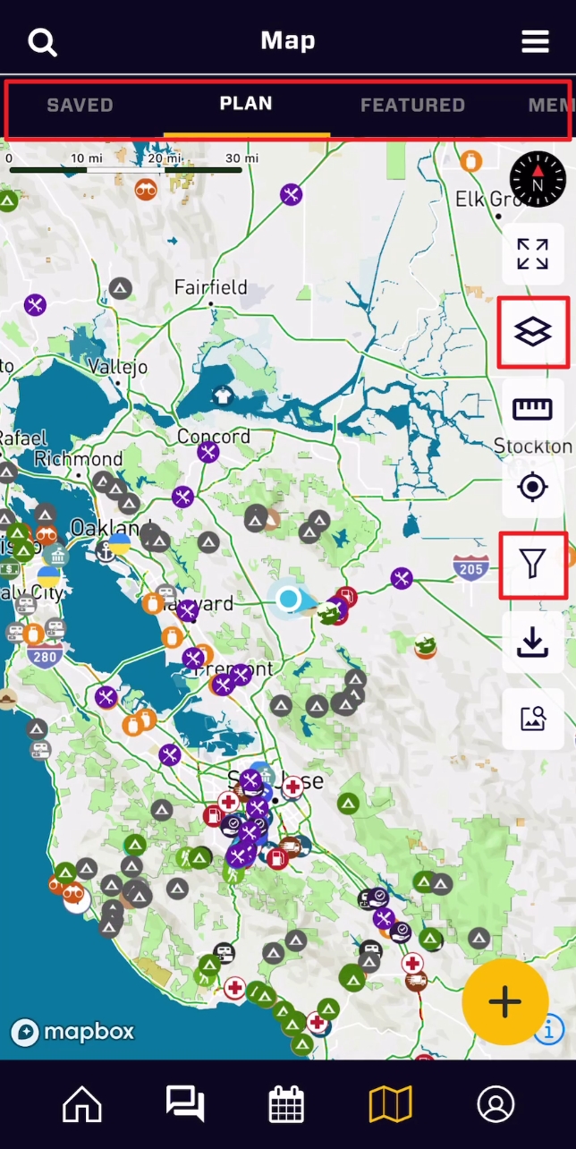
The Overland Bound One (OB1) default base layer is designed specifically for overlanders and adventure travelers and by default, the app lands on the "Plan" tab, which shows EVERYTHING! Each tab of the map has its own article.
There are three primary ways to filter map information:
Map Layers: Layers allow you to change the base map information, and the opacity of some of these layers. For example, if you want to overlay the USFS MVUM roads and trails with a Satellite layer.
Map Tabs: The map tabs change the functionality and area of focus on the map, for example, the Member tab allows you to contact members in your area.
POI Filters: The Points of Interest filters allow you to filter for specific location types you are currently looking for.
Lets take a look at Map layers and POI filters (each Map Tab has its own article).
Map Base Layers
The map layer icon looks like a couple stacked pieces of paper, just under the "expand Fullscreen" icon. In the Map Layers screen, there are two sections:
Map Type: The Map Types change the background base layer independent of the other layers. There are three layers depending on your use.
OB1 Adventure - The adventure layer is the default Overland Bound One base layer. It combines frequently needed information when you are navigating on the backroads. It is highly specialized for Adventure to highlight natural features, terrain, roadways, places, with unique iconography. The quality of the OB1 adventure layer should be immediately apparent. Global elevation and landcover data lie at the heart of the Overland Bound One Adventure layer. Including the best elevation and land cover sources from around the world: 24 datasets from 13 organizations, including the U.S. Geological Survey, Norwegian Mapping Authority, and Canadian GeoBase data portal combined into a set of hillshade, contour line, and land cover layers that provide the necessary context for path and trail information.
Satellite - Multiple sources of global satellite imagery from commercial providers, NASA, and USGS. Optimized for coverage and consistency, we continually add updated, high-quality, and attractive imagery as landscapes change. For the highest resolution imagery, commercial providers and open data sources provide greater detail wherever available. At resolutions up to 5 cm per pixel, aerial imagery delivers clarity and accuracy for cities, suburbs, and full countries.
Road - This clean background is meant to remove detail and clutter while you are navigating, but also prioritizes information for in transit needs. The high-contrast color system allows the viewer to easily recognize the map's features and quickly understand its hierarchies and classifications. The color system is fine-tuned to work perfectly at each level, and shifts subtly across zooms. It includes a wide variety of transit layers – from motorways to paths to ferries – and has been designed to provide an intricate rendering of their routes, intersections, and overlaps. In select cities and countries, The Road Style also features local public transit icons and highway shields to help orient the user and connect the map to their environment.
Overlays (aka Layers)
Overlays provide specific information, locations, and terrain features. This is where very specific information is provided. For example, one of the most trusted resources in North America for backroad travel is the USFS 2016 (yes 2016) raster image map. This is a known resource among veteran off-roaders.
layers may be turned off or on, and the opacity for some may be changed with the opacity slider. These layers will be added in addition to the Map Base Layer chosen. A brief rundown of the available layers (constantly expanding with community feedback):
Enhanced Topo - This darkens and thickens the altitude topographic lines on the map to easily see altitude changes from farther zoom levels.
Traffic - Realtime traffic.
National Forests - Notional forests with boundaries specifically called out, in addition to region fill.
BLM - Bureau of Land Management public lands.
BLM Routes - Bureau of Land Management routes, roads, and trails.
BIA - Bureau of Indian Affairs, Native American reservations.
USFS MVUM Roads/Trails - MVUM Roads and Trails - highly responsive vector display.
2016 USFS MVUM Roads/Trails - Raster image maps with highly detailed USFS features.
OLB Regions - Overland Bound Regions and Region names.
Points of interest
Points of interest are one of the most valuable resources in Overland Bound One, with more locations added by our huge community of overlanders and adventure travelers every day. Overland Bound also quality checks each location before approval to display publicly.
Filtering POI is done by tapping the filter icon along the right edge of the map. It looks like a funnel. Within the filters screen are a number of options to give you full control of the content on the map. Each time you change filters, be sure to "Apply Filters" at the bottom of the screen. Also, when a filter is applied, the home screen icon will turn bright yellow to remind you a filter is applied.
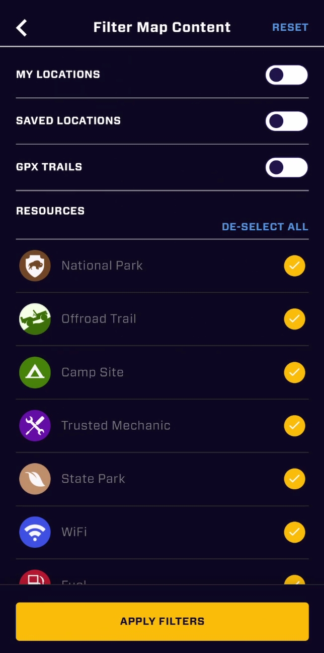
The reset button reset button in the upper right corner is your single tap to get everything back to a non-filtered state. In this mode, you will see everything in the "Plan" tab of the map. This has the most information.
My locations: This will quickly filter the map to only locations you have added. With my locations selected, you can also edit the different POI types. This allows you to drill down to "only camp sites I have added". Further, once selected, you will also see privacy options to display only your private locations, or public, or all, giving you even more control.

Saved Locations: Saved locations are any locations you save from the summary card of any POI location. You do this by tapping the Save icon in the summary card. This will also save the location to the "Saved" tab for easy access. This is a great way to plan a trip, saving POI you are interested in. See the Points of Interest article for more information on getting information about POI.
GPX Trails: GPX trails are routes recorded by our members. In order for these routes to be public, they must add information including difficulty and other important details. To turn the route lines off and on, select this toggle. In addition, you can filter trails by the level of difficulty they are turned on.
Resources: POI Resource types are a simple toggle. Some POI types are more prominent internationally, and may not be as relevant for your travels. The "De-select all / Select all" blue text allows you to easily toggle all POI icons on and off. Reminder: All blue text in OB1 is tappable, and does SOMETHING.